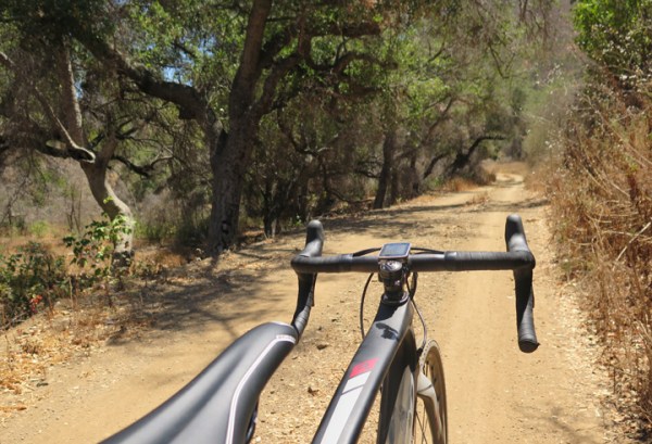
I like going places.
Roads are cool, but where there’s so many other places to explore on two wheels, you never want to confine yourself.
The western end of the Santa Monica Mountains is an area I have some familiarity with, but not so much on two wheels.
My prior fascination with trail running previously brought me out here to explore, enter a few races and even win one.
Entering Point Mugu State Park
It’s been years since I’ve been back, but coming out to Big Sycamore Canyon three months ago for a preview of Phil Gaimon’s Gran Cookie Fondo rekindled my interest.
I knew there were more trails to ride above, just I had little memory of how much and how tough.
Using Strava to help with my research, I applied my new rule about riding off road to NOT pick a trail that has been ridden less than 100 times.
In other words, I’ve made a lot of dumb mistakes in the past.
Big Sycamore Canyon flattening out.
Heading out of the trailhead at Potrero & Wendy, there’s a clear delineation how this typical suburb contrasts against an untouched landscape.
It’s a short, rolling mile until you turn a left to make it to the paved entry at Sycamore Canyon.
The view is a perfect entryway into the mountains with brown, grassy hills punctuated with crags.
From there you have one way to go: down. Straight down.
In other words, this is not a lot of fun going back up.
At mile 3, I turned off to climb up Ranch Center Road which was also paved, but in a good state of disrepair.
The panoramas opened up as I climbed making me think how much of this land will be turned into golf courses and condos when President Trump is elected.
Ranch Center Road not much of a road, but great to ride
The asphalt slowly gave way to dirt and by that time I was upon my first unfamiliar junction.
There was a properly placed sign, but I still had I feeling a should consult google maps to make sure I was going in the right direction.
 Okay. I stopped to check google maps and take a picture…
My path led me back downward into a small valley that was still recovering from fire damage.
The descent was also the rockiest portion of my ride, but it was pretty tame by gravel standards.
This was the prettiest land-only view of my ride as I enjoyed breezing through the shade of the sycamores.
The trees were a welcome way to cool off.
My next turn was my biggest mistake of the ride.
I should have continued down and then back up the Backbone Trail, but I wanted to avoid Sycamore Canyon as if crossing the same point twice was going to ruin my ride.
Instead, I decided to go up the trail known as “Hell Hill”, which is actually a misnomer because it feels more like a mountain.
It just got steeper and steeper to the point where my Garmin would waiver between 18% – 19%.
All I could do to distract from the pain was to get into pointless debates with myself, like “what tire pressure would a fire truck use climbing this hill?”
Hell Hill is a lot tougher once you make contact with it.
Right past the top, I reached another crossing where I ran into my first lifeform.
A runner was figuring out where to go on her sixteen mile run just five clicks in.
Just behind her, I could have pointed out the great trail options, but seeing how she had just one 20 oz water bottle and there was I high probability that I’d get her host, I tried encouraging her to take a path near where she came from.
A great place to run, but not give directions.
Did you think that worked?
I turned to the Overlook Trail and after a brief climb, the payoff views of the ocean started to emerge.
It was gorgeous, but he whole experience was accentuated by gliding down these smooth and gentle vistas on near perfect dirt:
This instantly became one of my favorite portions to ever ride experiencing how the road sweeps right into the landscape.
The Overlook Trail ends on Big Sycamore Canyon Trail and I turned towards the ocean heading to the campground at Point Mugu for water and a little break.
I started the return by taking the trail back up. Maybe it was riding on a gravel bike versus a roadie, but the dirt looked a lot less rocky from when I rode it previously.
It’s only a 4.5 mile section of dirt, but it has a really gentle climbing grade.
Rolling back up Big Sycamore Canyon
I really can’t think of any other spot that’s as flat as this coming off of PCH. You could say the start of Topanga Canyon, but it definitely doesn’t feel as pleasant riding it.
Before I knew it, I was back onto pavement biting my lip getting ready for that last climb up.
As bad as this 10% climb was, it sure felt shorter than the time before and I was glad to make the final stretch back to my car.
This really felt like the perfect ride(if I had made the detour around Hell Hill) and I feel like this is the proper place to initiate someone into the world of gravel with the gorgeous views, well kept dirt and easy grades(except previous disclaimer).
I’m super anxious to come back again in November for Phil’s Fondo when the landscape should hold greener tones, but I imagine I’ll be back before that.


